|
Home | Blog Index | Blog Archives | Christianity & Faith Essays | Storm Chasing Essays
Upslope Snow in the Appalachians: The Basics
The upslope effect is an important factor in West Virginia weather, particularly during the winter. I thought I'd take some time to give a brief description of what happens during upslope-influenced weather patterns.
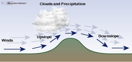
Upslope flow is what meteorologists call winds at and near the surface that encounter mountains, forcing the moving air to rise up and over the wind-facing slopes. Just like a dirt bike driving up a ramp, upslope flow gives the horizontally-moving air a vertical component to its motion. Orographic lift is another term for this upslope-enhanced vertical motion. When air is forced upward, it is cooled - causing any moisture in the air to condense into clouds and precipitation. The more perpendicular the winds are to the mountains, the greater the upslope forcing will be.
Appalachian upslope flow & Great Lakes moisture
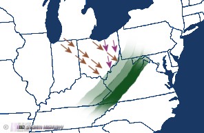
Weather in and around the Appalachian mountains is influenced by upslope flow, the effects of which can begin as far west as the Ohio River in West Virginia as the terrain begins to rise from the flat Midwestern landscape. Upslope flow can trigger thunderstorms in the summer and generate snow showers in the winter. While most upslope events are on the west side of the mountains due to the prevailing westerly winds, occasionally upslope patterns can develop on the east side of the Appalachians when winds turn southeaserly or easterly. On the downsloping side of an upslope wind configuration, there is usually no precipitation and in many cases, clear skies!
While upslope snowfall can be fed by ambient moisture already present in an air mass, the Great Lakes play a role in many Appalachian upslope snow events by 'loading' the air with moisture as winds pass over the surface of the water. The winds act as a conveyor belt, carrying the plume of lake moisture to the mountains where it is then 'squeezed out' by upslope lift in the form of rain or snow. In this way, many of West Virginia's upslope snow events are a type of lake-effect snow, far away from the actual lakes.
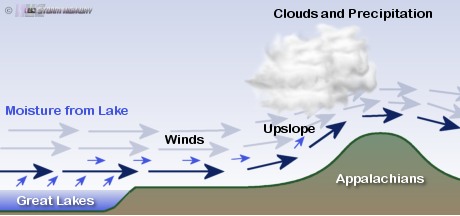
The wind direction and trajectory plays an important part in the strength of upslope snowfall in West Virginia. The best patterns come from northwest winds that carry moisture straight from Lake Michigan directly into the mountains at a 90-degree angle. Northerly winds can bring Lake Erie moisture southward, though the lesser angle at which these winds hit the mountains tend to limit the strength of the resulting snowfall. Northerly and northwesterly winds are typical following the passage of strong cold fronts in the fall and winter.
Upslope snow bands in West Virginia sometimes have a similar appearance as classic lake-effect bands. The following radar animation shows Lake Michigan-fed upslope snow bands over the Summersville-Frametown areas. Just like their lake-effect counterparts, these bands can persist for hours and sometimes even contain lightning and thunder.
Notice the red-orange-yellow-purple-white color scheme in the above radar image. This is an indication that the radar is in its more sensitive 'clear air mode', as opposed to 'precipitation mode' when the more familiar green-yellow-orange-red scheme is used. The radars are normally kept in 'clear air mode', programmed to automatically switch to 'precipitation mode' only when the radar detects a certain amount of rainfall coming within range. Snow bands tend to have weaker-looking radar echoes than rain bands of the same size, which means the radar will often remain in 'clear air mode' during most of an upslope snow event. However, though snow-producing clouds have weaker echoes than rain-producing ones, the impact on the ground from a snow band is usually greater than a rain band of the same size. Even a heavy snow band that doesn't trigger the radar's 'precip mode' can still produce blindingly heavy snow and rapid accumulation rates.
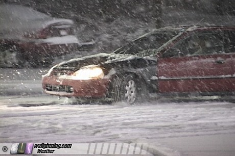
Just like a lake-effect band, an upslope snow band can be very narrow with no snow occuring just a few miles to its north or south. The following image is from a Lake Michigan-fed upslope snow band over Pinch, West Virginia, which produced 3 to 4 inches of snowfall in less than 2 hours over the Elkview, Pinch and Clendenin areas of Kanawha County on January 28, 2007. Just 8 miles to the south, downtown Charleston saw no snow at all.
Upslope snowfall doesn't always form in lake-effect-like bands, though. Many times the snowfall will form in a widespread 'stratiform' fashion, with heavy snow blanketing a corridor up to 100 miles wide. These conditions usually require an air mass already rich with enough moisture to expand beyond the usual narrow lake-supplied corridor.
Predicting upslope snow
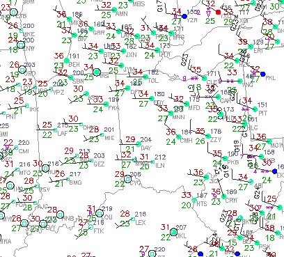
Forecasting upslope snow is a fairly simple process. The first ingredient needed is a good period (6 to 12 hours or more) of low-level winds carrying air straight into the Appalachian mountains. The closer to a 90-degree angle that the wind hits and runs over the mountains, the better. Secondly, a source of moisture must be present. The air mass approaching the mountains must have sufficient moisture content to produce precipitation as the orographic lift kicks in. This can be enhanced (or provided completely) by the air moving over either Lake Michigan or Lake Erie before it hits the mountains. Using METAR wind observations (automated weather stations), you can estimate the path the lake moisture plume will take across Ohio and where it will impact the mountains.
Third, you need freezing temperatures at the 850mb level (in West Virginia and Ohio, this is the level of the atmosphere just above the surface). Freezing temperatures at the surface are needed for the snow to accumulate.
Computer models such as the GFS and WRF (see our data links page) can help you predict when and if these ingredients might materialize. The models can show you their predictions for surface and 850mb temperature (will the air be below freezing?), surface and 850mb wind speed and direction (how strong will the upslope flow be, and will there be a good fetch of wind from the lakes to the mountains?), and QPF or total precip (how much cumulative precipitation is expected?). Remember though, the models are often incorrect in their assesments and must be taken with a 'grain of salt'. As the event gets closer in time, you can start looking at the METAR observations to see if what the models are predicting is actually happening - are the winds the right direction? Are the temperatures in line with the model output?
A good moisture plume off of either of the lakes will often result in a narrow band of thick clouds with snow showers or flurries streaming toward the mountains. You can use radar, satellite images and METAR data to locate these. Remember though, that upslope bands don't move in from Ohio like a thunderstorm or rain shower will. They usually form abruptly overhead 'out of the blue', typically between the Ohio River and the I-79 corridor eastward into the high mountains. They can form in a matter of minutes and catch drivers and meterologists alike off guard. You can estimate where they might form by following the lake moisture plume to the Ohio River.
Even with all of this information, you'll find that accurate forecasting of upslope snow will be difficult. The models will often be off in their predictions, requiring you to pay attention to the evolving conditions leading up to the 'main event'.
GO: Home | Storm Expeditions | Photography | Extreme Weather Library | Stock Footage | Blog
Featured Weather Library Article:
|