|
HD VIDEO: Chicago triple lightning skyscraper strikes: Watch video
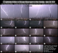
HD VIDEO: Chicago skyscraper lightning stills timelapse: Watch video
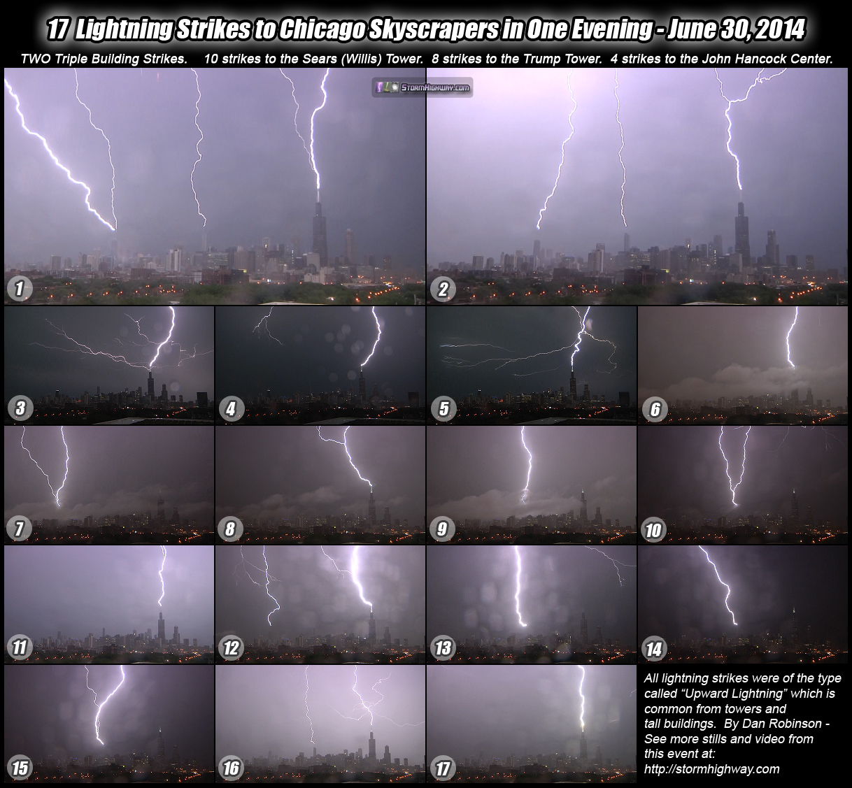
Infographic: 17 lightning strikes to Chicago skyscrapers in one night
FAQ: Chicago Skyscraper Lightning FAQ
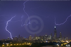
 CHICAGO - I fulfilled a major life photography/video goal on this chase with a storm event that exceeded my best expectations. The June 30, 2014 storms in Chicago produced 17 upward lightning discharges involving one or more of the three tallest buildings in the city - the Sears (Willis) Tower, Trump Tower and the John Hancock Center. Two of the discharges produced strikes to all three buildings simultaneously, one of which I captured on a clean DSLR still image. In total, I captured video of all 17 upward flashes, and still images of 14. It was the incredible 'lightning bonanza' I'd always hoped to get in Chicago, but had eluded me all of these years. CHICAGO - I fulfilled a major life photography/video goal on this chase with a storm event that exceeded my best expectations. The June 30, 2014 storms in Chicago produced 17 upward lightning discharges involving one or more of the three tallest buildings in the city - the Sears (Willis) Tower, Trump Tower and the John Hancock Center. Two of the discharges produced strikes to all three buildings simultaneously, one of which I captured on a clean DSLR still image. In total, I captured video of all 17 upward flashes, and still images of 14. It was the incredible 'lightning bonanza' I'd always hoped to get in Chicago, but had eluded me all of these years.
(Click on any image for a larger version with print ordering links)
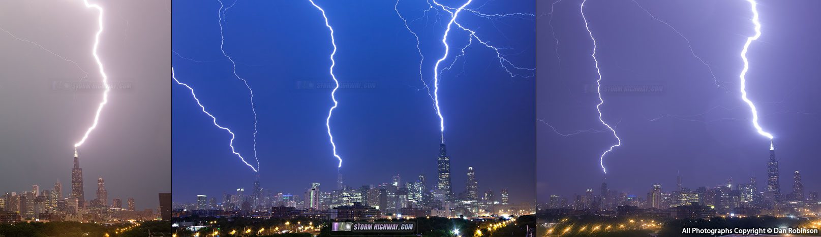
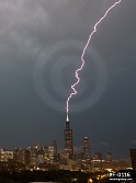
Two of three strikes to the Sears (Willis) Tower during the first round of storms at twilight (As a side note - most Chicagoans despise, and do not officially recognize, the renaming of their most prominent landmark to "Willis Tower". Even though I'm an 'outsider' of sorts, I began this project before the name change and also feel the same sentiments -so I will give the "Sears" name priority in all of my imagery and video descriptions):
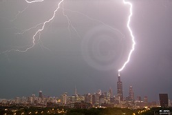 
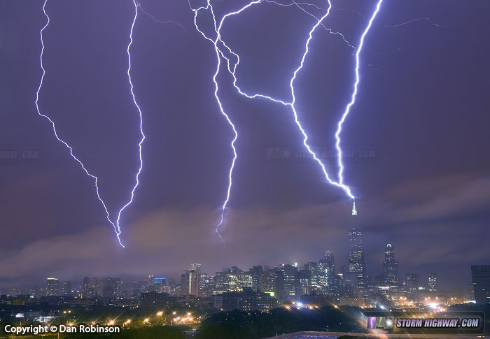
Now for the main show with the second round of storms! This first image of all three tall skyscrapers being hit simultaneously is a single exposure, not a stack composite! The video linked above shows this discharge in the first clip (shown in both realtime and 10% speed) if there is any remaining doubt about whether this is real. If the video is somehow not enough proof, another photographer also captured the same event from a different angle. Note that while I routinely stack lightning shots when it is possible, this particular one is NOT a stack:
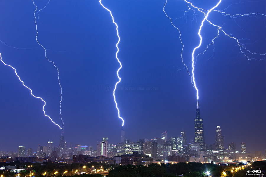
These next two images are stack composites of multiple individual frames. These are the only two stacks I assembled from this event. (My stacked images are clearly marked as such, and all stacks begin with "ST" in the catalog number.) This one is a composite of four single-strike discharges - two to the Sears (Willis), and one each to the Trump and Hancock. These four strikes happened while fog/low clouds partially enshrouded the skyline:
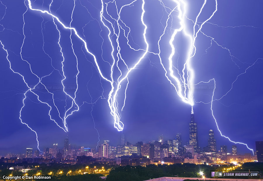
Now - I assembled this next stack not so much for its artistic value (it is too over-the-top for that) but to show in one image how truly crazy this event was. This is a 12-frame composite image of all of the strikes captured during the second round of storms:
Here are the images of individual discharges:
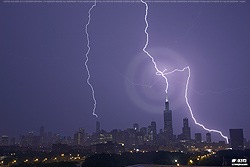 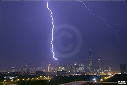 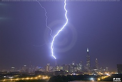 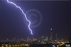 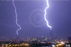 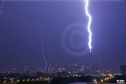 
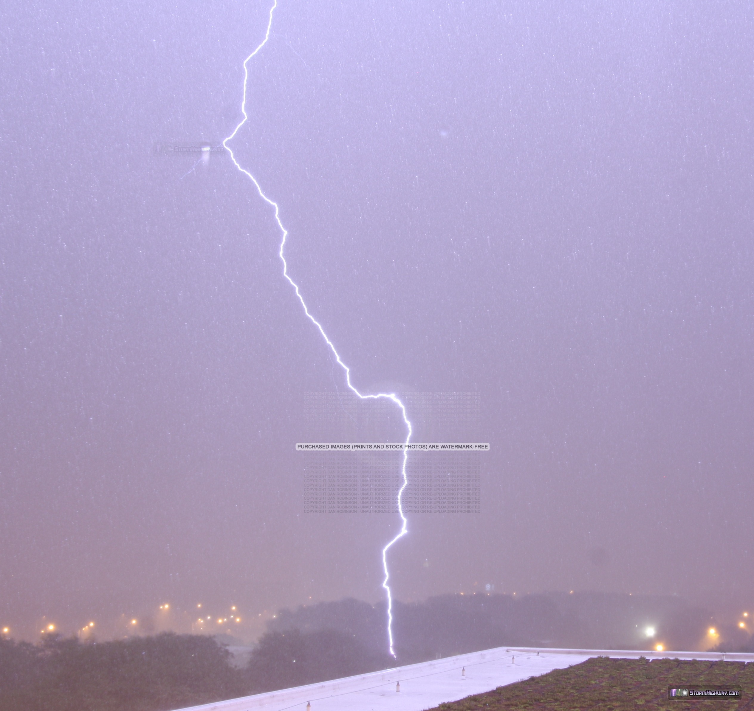
Image of a close lightning strike to a tree a few hundred feet away, during the heavy core of the second round of storms:
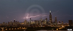
And finally, two nice discharges behind/over the skyline that did not trigger upward flashes (one each from the first and the second MCSes):
Backstory/chase account for this event:
Back in 2005, I had just purchased my first HD video camera. I decided I wanted to capture high-quality still and video images of lightning striking skyscrapers in Chicago. I was determined to succeed, even though at the time I was living in Charleston, West Virginia, necessitating an 8-hour drive to the city. This trip was the tenth of my "Chicago lightning chases" in 8 years. Previous trips had resulted in either: no storms at all, storms that died before reaching the city, storms with uncooperative lightning or no building strikes, storms with wind shifts that prevented shooting by blowing rain onto my cameras, or lightning that was just below my threshold of quality to satisfy the ultimate objective. Many of the trips involved long stays and 48-hour 'marathons' that included sleeping in my car.
Prior to June 30, 2014, the best I did was the July 20, 2006 trip - in which the Sears and Hancock towers were both struck simultaneously, twice (the Trump Tower had not yet been built then). I was only able to capture those two discharges on video, as it was after sunrise and I was shooting 35mm slide film on a manual SLR camera. The video turned out OK, but it wasn't quite what I was after. I also wanted a nice still image. So, I pressed on with the project. Moving to St. Louis in 2010 shortened the drive by 3 hours, but it was still a marathon to drive up, attempt to shoot a storm, and return.
Even though I felt like I had a good handle on the meteorological setups needed to produce the right kind of storms for what I needed, that is, numerous upward lightning strikes to the buildings - it still took me 8 years. The ideal type of storm for this actually does not happen very often in Chicago - maybe once or twice a year. A strong MCS (mesoscale convective system) needs to develop in western Iowa or Minnesota in the early afternoon, arriving in Chicago sometime after sunset, but before sunrise. It is much more difficult to shoot stills of lightning during the day, so I needed nighttime storms. Since most of these systems happen during the short nights of summer, the window for nighttime storms is small. A complex of storms has to form at just the right time and place in Iowa or Minnesota, then arrive in Chicago as a fully mature MCS with what is called a "trailing stratiform" region. This is the area of electrified light rain behind the heavy 'squall line' of thunderstorms. The bigger the "stratiform area" stretches out behind the line of storms, the longer a potential upward lightning event will last and the more discharges will occur. If the storms are not yet mature enough and don't have a trailing stratiform region, there may only be one or two upward lightning flashes, or none at all.
Conditions seemed ripe on June 30 for a good upward lightning event in Chicago. A powerful MCS was forecast to form in Iowa, tracking east into northern Illinois as a mature bow echo. Complicating the chase, however, was that there was a good risk for tornadoes in southern Iowa and central Illinois where strong instability was developing along an outflow boundary. The tornado risk was close to home, and one I did not want to miss. I left home at 9AM and arrived in southeastern Iowa after noon. Fortunately, as the day progressed, it became apparent early on that the tornado risk was diminishing. The MCS was developing faster than forecast, with strong outflow along it removing supercell tornado potential. No other leading storms were developing out ahead. This was my cue to abandon the tornado chase and head east for Chicago skyscraper lightning.
On my way east, the MCS was hot on my tail. I got caught by its leading edge as I made my way to I-80 near Peru, but thankfully was able to get back out ahead once I was on the interstate. The storm's core still beat me into the city by about 10 minutes, thanks to the northward jog I needed to take on I-57 to get downtown. I arrived at my longtime setup location (since 2006) just in time for the trailing stratiform region, in which three strikes to the Sears (Willis) Tower occured at twilight. I captured still images of two of these (first two images above). Unfortunately, the main trailing stratiform region in the MCS was tracking north of Chicago into Wisconsin, limiting the duration of upward lightning potential.
The main show, however, was still to come. A second line of storms approached from the west, with a much larger trailing stratiform region moving right at the city. And it was nighttime! The second storm's leading core was full of intense cloud-to-ground lightning - and I rolled both cameras to document this stage. I captured one close strike on both still and video. The electrified trailing stratiform region arrived, and stayed over the city for almost two hours! This was about as good of a storm configuration as I could have hoped to get. The only problem I had during shooting was wind-blown rain, which is a pest during any storm. Lens raindrops marred some of the video and stills, but the best shot of the night was miraculously raindrop-free.
I encountered a major traffic jam on I-55 where the interstate had flooded, but finally detoured around it. I had planned to get a hotel once outside of the city, but I was awake enough to drive all the way back home - ending the 22-hour chase at 6AM.
Storm Chasing & Photography Index
 About the Author: Dan Robinson has been a storm chaser, photographer and cameraman for 30 years. His career has involved traveling around the country covering the most extreme weather on the planet including tornadoes, hurricanes, lightning, floods and winter storms. Dan has been extensively published in newspapers, magazines, web articles and more, and has both supplied footage for and appeared in numerous television productions and newscasts. He has also been involved in the research community, providing material for published scientific journal papers on tornadoes and lightning. Dan also holds an active Remote Pilot Certificate from the FAA (Part 107) for commercial drone operation. |
was watching here in roseville ca. saw video clip on fox 40 news this morning.
- Posted by bababooey | | |
You got the money shot right there! Excellent shot of 3 towers struck by lightning! You also called the sears tower by its right name. I don't care if it's called the willis tower now, I'm always going to call it the sears tower!
- Posted by Tim | | |
Nice! I got it as well at flickr.com/photos/cshimala/14548339045/
Back on June 23rd 2010 I got it on video which you can view at vimeo.com/12816548
- Posted by Craig from Chicago | | |
Fantastic Set!!!
- Posted by Steve from Atlantic City | | |
Thanks everyone! Craig, Congrats on your catch! I linked to it above. I love the vantage point you have there. I'm especially glad you also got it, as it's proof against everyone calling it fake!
- Posted by Dan R. from New Baden, IL | | |
Awesome photography Dan. Well done. Did you just happen to be in Chicago, or did you travel there specifically for what they're now calling a "Derecho" event. And speaking of Derecho's.. a much more impressive one is proceeding through Missouri tonight (July 7,8).
- Posted by John from North Texas | | |
It was an impressive one, john. Too bad it fizzled out before reaching st. Louis like everything else this year. In my opinion, this was the worst year ever for storms here. Oh well, maybe next year.
- Posted by Tim | | |
OH YES BALL LIGHTENING IS A REALITY. My husband and I experienced seeing it roll toward our home in Annapolis, Maryland in 1976. The ball rolled away from our home and hit a neighbor's home with a loud bang. The home caught fire.
- Posted by Nancy Todd | | |
|