Dozens of upward lightning strikes to Oklahoma City towers - April 27, 2024

ABOVE: Upward lightning in Oklahoma City on April 27, 2024
6000FPS CHASE VIDEO: Negative cloud-to-ground bolts at Ponca City, OK
4K CHASE VIDEO: 4K realtime and 1,502fps slow motion of upward lightning in Oklahoma city
I saw a tornado, but the lightning catches were my best of this day. I started in Ottawa, Kansas, indecisive about the day's target. The better parameters were going to be along and ahead of the dryline in central Oklahoma. Satellite/radar showed that area getting plenty of sun, with the ongoing storms to the northwest of it not looking to sweep through and wipe it out early. The problem with central Oklahoma during a big tornado event on a Saturday is that the number of chasers and locals on the roads would potentially be high, especially if there were only one or two storms. So, I decided to target the northern end of the risk area along the Kansas border. Models were also insistent on a large squall line with trailing stratiform precip in Oklahoma City and/or Tulsa, so I wanted to get to either of those locations in time to capture the upward lightning show.
Supercells were already evolving from the morning storms as they crossed I-35. I intercepted the best-looking one at Dexter, KS as a huge RFD surge produced a tornado as it curled back into the meso. The storm was also producing a barrage of positive CGs, many far ahead of it into clear air - a few that were close.

Unfortunately, the storm was HP (high-precipitation) and this circulation was completely rain-wrapped. I parked on Highway 166 for a while, hoping that the rain would clear out on the back side of the meso to reveal the tornado - but this didn't happen. I waited for two new storms to come up from the south between there and Cedar Vale, but they were cold and outflow dominant. The outflow was also consolidating and surging southward, which would undercut additional storms coming up from the southwest. I decided I needed to get south of this, so I headed south on Highway 15 into Oklahoma.
The south end of the outflow was visible intersecting a new supercell updraft west of Foraker.

I turned east to stay just ahead of this (thankfully the road was paved). The forward flank tail cloud was racing into a new mesocyclone and wall cloud to my south. Intermittent funnels appeared under the wall cloud. Multiple areas of rapid spin developed on this boundary, including right ahead of me and nearly overhead. This was an amazing sight overhead! As the meso moved northeast, it produced several weak tornadoes under the center of the main circulation. These manifested as debris clouds and areas of spray kicked up from the wet fields in the center of rotating rain curtains. I did not get any good video of these, and they were not very visually spectacular to begin with.

The east-west road past Foraker eventually dead-ended into a muddy north-south road, so I had to let the storm go.
I drove back south to Ponca City to get in front of the long-lived supercell that had produced tornadoes down near I-40 a couple of hours earlier. It had weakened considerably, but I felt it might eventually recover as the low-level jet intensified. But, I had some time before it arrived and that would occur, so I was able to stop for a quick dinner/coffee. As the storm moved into town, it began producing a flurry of tall negative cloud-to-ground lightning strikes way out ahead into clear air. I was able to catch 2 of them on the high speed camera at 6,002fps, one which is now my best high-speed lightning catch:
The lightning barrage here signaled the expected intensification of both this storm and a new supercell to the south. Despite this, the original storm looked cold, and motion was weak. I decided to drop down to the new storm, which was looking much better on radar. It too, was cold-looking with no motion observed in the updraft or developing mesocyclone. After the second storm moved through Ponca City, there were no good roads to stay with it. The expected squall line evolution seemed to be taking place to the south with electrified stratiform developing and moving toward Oklahoma City, so I decided to abandon the Ponca City storm and head south into OKC for upward lightning.
Although I had a hard time battling wind-blown rain in Oklahoma City, the upward lightning show was spectacular. I captured many good stills, 4K video and high speed 1,500fps shots. There were several slow positive upward flashes. I lost count of how many there were, but there were well past 30. The $K and high speed video has been posted to my Youtube channel.
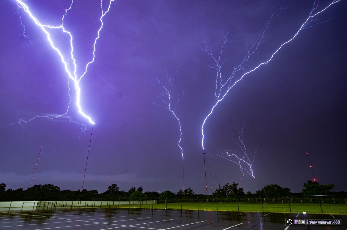


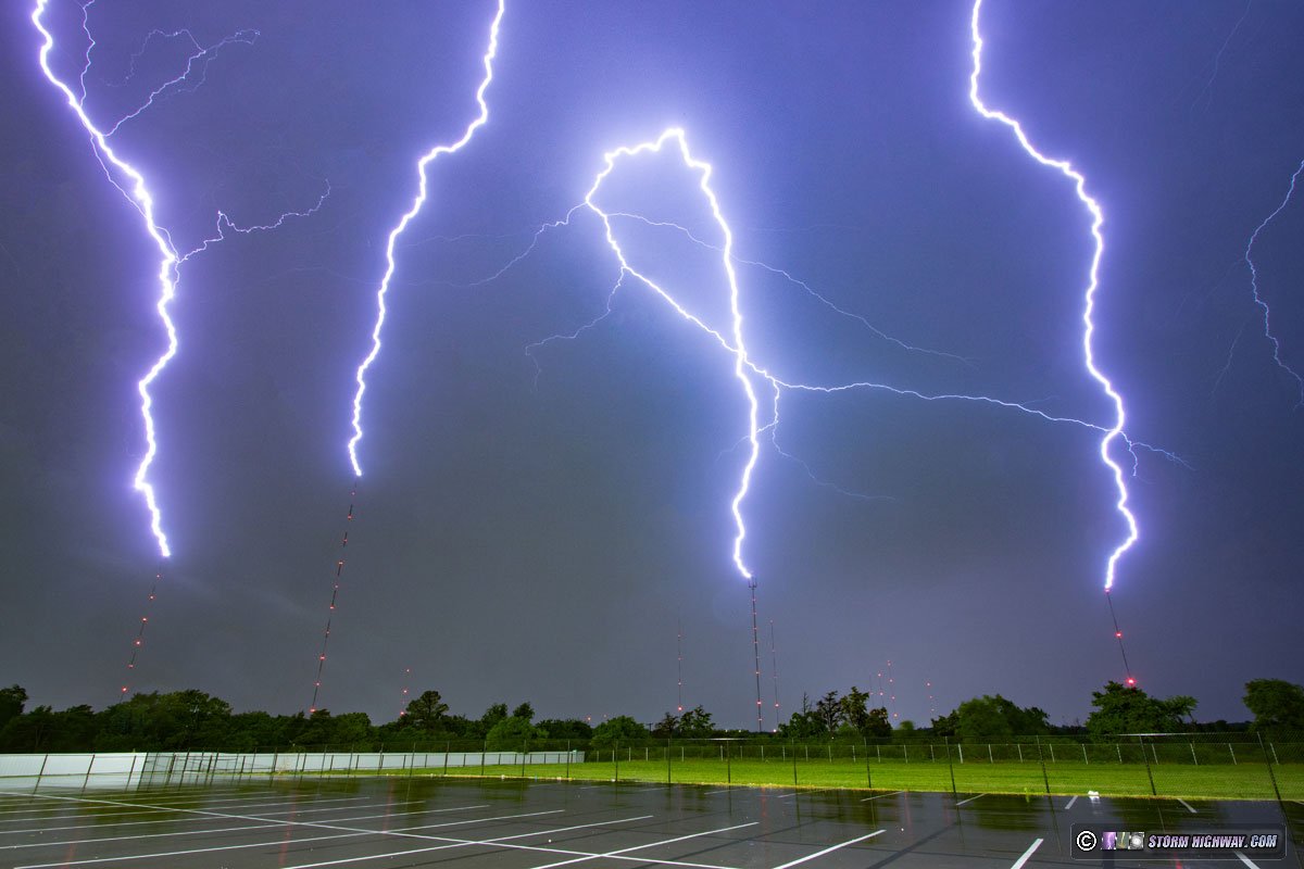


This downward positive CG connected to one of the towers:

There were also some sky-filling negative anvil crawlers:

The stratiform lightning mostly moved off to the east by 2AM, so I packed up and stopped for the night in the city.
GO: Home | Storm Expeditions | Photography | Extreme Weather Library | Stock Footage | Blog
Featured Weather Library Article:
|