|
Home | Blog Index | Blog Archives | Christianity & Faith Essays | Storm Chasing Essays
Earthquake chasing: the top "targets" to experience/document a major quake
Is it possible to "chase" an earthquake in the same sense that storm chasers do with hurricanes, supercells and tornadoes? The simple answer is no. Earthquake prediction, at least anywhere near the useful levels that we have with weather forecasts, is a virtual impossibilty with the knowledge and instrumentation we have now. There is no way to know when and where the next mainshock (the main event of a large quake) will be - the only feasible "earthquake chasing" you could do is to immediately travel to where a major event has just occurred (within 24 hours) in order to experience some of the larger aftershocks.
That being said, with our ever-improving knowledge of active faults, tectonic plate motion, records of past earthquakes and measurements of ground deformation, we can state with varying degrees of confidence where future large earthquakes are likely to occur. Thus, "chasing" one of these events would involve moving to one such location, and then waiting for the earthquake to happen. These "earthquake chases" could take several years, or even decades, to complete - and just like with storm chasing, a "bust" is possible (no earthquake occuring in your target within your lifetime).
If one really wanted to embark on an earthquake chase within the United States, where would you go? This list covers the optimal places in the US to embark on a chase with the end goal of experiencing/documenting a magnitude 6.0 or greater event. Keep in mind that major quakes can and do often occur in places that they are not expected, and it's also possible that none of these "targets" will see a major quake in our lifetimes. So, this list is by no means a "forecast" of the next major US earthquake.
#1: Southern San Andreas Fault - Parkfield to the Salton Sea, California
My first pick as a "target" for an earthquake chase is the southern San Andreas fault segment that runs from Parkfield to the Salton Sea in southern California, just north and east of Los Angeles. (View an interactive map of the entire San Andreas fault trace). Parts of the Gorman, Palmdale, San Bernadino and Desert Hot Springs areas lie directly on top of the fault.
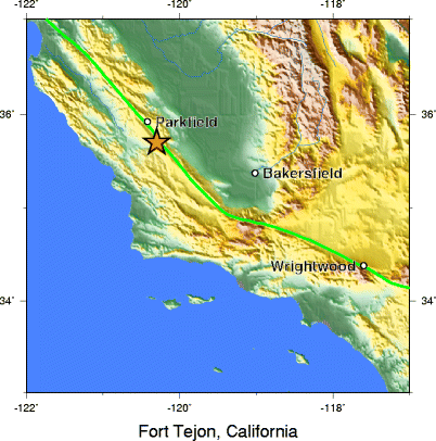
1857 Fort Tejon earthquake epicenter map
Geologic evidence shows that this segment of the San Andreas fault ruptures in a major earthquake (magnitude 7.0 or greater) once every 150 years or so. The last event to occur on this segment of the fault was the M7.9 Fort Tejon earthquake of January 9, 1857. With no quakes on this "locked" segment of the fault in over 160 years, where it is known that tectonic strain has continued accumulating unabated, scientists are in confident agreement that the southern San Andreas is primed for a major rupture similar to the 1857 event. It is also believed that the resulting event could slip beyond the Fort Tejon rupture zone, resulting in a quake of magnitude 8.0.
The entire Los Angeles region will experience strong to severe shaking during a southern San Andreas earthquake (watch this shaking intensity simulation), but locations directly along the fault will feel the most violent ground motions along with prominent coseismic (meaning happening during the quake) surface ruptures. The 1857 Fort Tejon earthquake produced a surface rupture along the fault with offsets of up to 9 meters (30 feet).
Scientists have assigned the probabilities for a M7.0+ major southern San Andreas quake at 75% over the next 30 years. That gives a long-term resident along this section of the fault the greatest chance of experiencing such an event within the next couple of decades, possibly more than anywhere else in the USA. The 1857 event was preceded by a series of foreshocks beginning 9 hours prior to the M7.9 mainshock. A similar foreshock sequence might give a "chaser" who lives within a couple of hours of the fault enough time to make his/her way to the immediate fault zone to document the event (someone living that close would still feel the mainshock, just at a lower intensity).
PHOTO TOUR: Southern San Andreas Fault - I traveled to California to document this segment of the San Andreas Fault, and produced this photo tour where you can follow along and see the highlights.
#2: Southern Cascadia subduction zone - Coos Bay, Oregon to Aberdeen, Washington
The last major earthquake on the Cascadia fault (which parallels the coast just offshore of the Pacific northwest states and British Columbia, Canada) was in 1700. Scientists believe this event was close to magnitude 9.0, which, as is typical with large subduction zone events, produced a major tsunami and land subsidence in the region. The recurrence interval for ruptures on the southern segment of the Cascadia fault is on the order of 240 years, and GPS monitoring is currently recording ground deformations that indicate strain is building. All signs point to this region being another prime location for a major earthquake and tsunami being possible within the next 30 years.
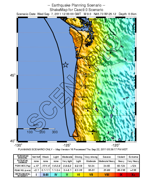
Expected shaking intensities of a future 9.0 Cascadia earthquake
While the southern Cascadia fault zone is the most likely segment to rupture next in this region, it is not known whether this event will propagate the full length of the 1700 fault plane to the north. The result would mean a smaller-but-still-major event of M7.0 to M8.0.
Since the primary Cascadia fault plane is offshore, ground motions on land will not be as violent as they would be for a location right on top of a strike-slip fault such as the San Andreas, and there will be no surface rupture (unless the main event triggers slip on faults inland). That being said, Cascadia would still be my #2 choice for a long-term earthquake documentation chase. #3: Hayward Fault - Fremont to Oakland, California
Like the southern San Andreas, the Hayward Fault is also classified by scientists as a top concern for a major high-impact event that could occur at any time. The locked portion of the fault, which runs from Oakland through Fremont in the eastern San Francisco Bay area, last ruptured in a magnitude 6.8 earthquake on October 21, 1868. With an average historical rupture recurrence interval of 140 years, the Hayward fault is thought to be overdue for its next earthquake.
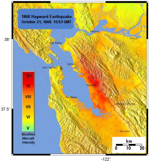
Shaking intensities of the 1868 Hayward Fault earthquake
Unlike the southern San Andreas fault which passes through relatively sparsely-populated areas, the Hayward lies directly underneath a dense population center. As a result, despite the expected imminent earthquake being smaller in intensity than the southern San Andreas' threat, the human impacts from a Hayward rupture will be far greater.
A Hayward earthquake similar to the 1868 event will likely result in significant surface rupture through the densly-populated region. The northern segment of the Hayward fault is "creeping" (continually moving slowly without sudden earthquake-generating slips), and has produced a constantly-moving surface offset in the Berkeley area that can be witnessed today in curbs, sidewalks and other items crossing the fault. #4: New Madrid Seismic Zone - Blytheville, Arkansas to Sikeston, Missouri
The NMSZ is best-known for its sequence of three significant earthquakes exceeding magnitude 7.5 in 1811-1812. Trench excavations in the region have revealed evidence of similar earthquake sequences in the past, with a recurrence interval of 400 to 500 years. While we are probably only halfway through the recurrence interval for another major New Madrid sequence like the one seen in 1811-1812, we have reached/exceeded the expected interval for smaller quakes of magnitude 6.0 or greater which are known to occur in the NMSZ.
While this region made my list for an earthquake chase target thanks to the likelihood of a magnitude 6.0 in the next 2 decades, the inability to pinpoint a specific fault source for such a quake - and the probability that no surface rupture will occur - brings it in at the fourth spot on my list. #5: Eastern Aleutian subduction zone - Sand Point to Perryville, Alaska
From 1938 to 1996, the entire of Alaska's Aleutian subduction zone has been ruptured in a series of earthquakes - except for one small patch in the eastern segment of the island arc. This unruptured portion of the active fault is called a "seismic gap", and these gaps are often considered to be primed for future earthquakes. This segment, called the " Shumagin Gap", last ruptured between 1899 and 1903. Since the rest of the subduction zone is known to have earthquake recurrence intervals of 30 to 50 years, the Shumagin Gap is considered a likely location for the next major event in Alaska.
An "earthquake chase" here would be rather difficult due to the remoteness of the towns and impracticailty of living in this area full-time, so I've placed it last on my list of hypothetical targets.
GO: Home | Storm Expeditions | Photography | Extreme Weather Library | Stock Footage | Blog
Featured Weather Library Article:
|