|
Home | Blog Index | Blog Archives | Christianity & Faith Essays | Storm Chasing Essays
Snow forecast update
Winter weather has arrived in force this week for large parts of the USA, and West Virginia should be next in line to get its share of snow.
For tonight and Monday:
The following image is the METAR observation map from 7:23PM EST, plotting surface data from the network of weather stations across the country.
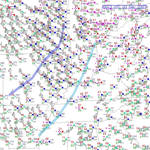
I'll start with a little METAR primer, in case this map looks like greek to you. Each station, marked by the little circles, is reporting wind direction (the direction the barbs point), wind speed (the number and length of the ticks on the barbs, with top gusts marked with black numbers), temperature (red numbers), dewpoint (green numbers), and weather type (purple symbols). There are dozens and dozens of possible METAR symbols for all types of weather, so for now I'll only talk about the ones on this map (you can see a list of all of them here). The clusters of purple dots next to each station indicates rain. Two dots means light rain, three dots = moderate rain, and four dots means heavy rain. Snow is indicated exactly like rain, but with asterisks instead of dots. On this map, the only snowfall currently being reported is way up in Minnesota. The symbols show that rain of varying intensity is ongoing across the region, including in Ohio, West Virginia and Pennsylvania. The color of each station circle indicates the aviation visibility conditions, green being the best, blue meaning decreased visibility, red meaning bad visibility, and purple being the worst. (By the way, you can look at current METAR maps at our data links page).
I have drawn blue and dark blue lines on this map to show the location of the cold front (light blue line) and the freezing line (dark blue line). Notice how the wind abruptly shifts from southwest to northwest behind the cold front, with a strong field of cold northwesterly winds behind the front. Looking at the current regional radar image, we can see the precipitation that the METAR map is showing.
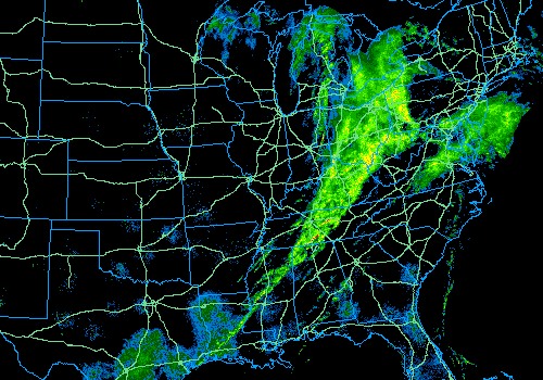
What I see with these two pieces of information is that there is no precipitation behind the cold front, and more importantly, no precipitation back where the air drops to below freezing in Illinois and Missouri. What this says to me is that at first glance, the potential for snow for West Virginia tonight and into tomorrow looks slim. Now remember how I talked about upslope snow? Take a look at the winds behind the cold front on the METAR map above. While not the greatest for lake moisture conveyance from Lake Michigan toward West Virginia, the winds will have an uplifting component to them as they strike the Appalachian mountains. While the chances are slim tonight, I wouldn't be surprised to see a few upslope snow showers form toward dawn as that cold northwest wind arrives.
For Tuesday and Wednesday:
Tuesday and Wednesday look like the first real chance for a bona-fide statewide snowstorm in West Virginia. With freezing cold air in place, a 'clipper' type system is forecast to pass on Tuesday and Wednesday. 'Clipper' is a name for a Canada-originating low pressure/cold frontal system which sweeps southeast into the US. The models indicate a good swath of precipitation with the clipper, which should be all snow areawide due to the cold air in place.
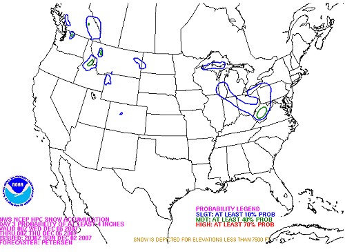
The official NOAA HPC snowfall forecast for Wednesday calls for a 40% chance of a snow accumulations of four inches or greater across most of the state of West Virginia, including Charleston, Beckley and Clarksburg.
Icy road season takes its toll
ARTICLE LINK: Detroit Free Press
This week's winter storm has been responsible for at least 10 deaths across the country due to icy roads. That's a fatality count close to that of the Greensburg, Kansas F5 tornado back on May 4.
GO: Home | Storm Expeditions | Photography | Extreme Weather Library | Stock Footage | Blog
Featured Weather Library Article:
|