Tornado outbreak in Nebraska and Iowa (Waverly, Omaha, Beebeetown, Minden, Osceola) - April 26, 2024

ABOVE: Tornadoes in Nebraska and Iowa during the April 26 outbreak
4K CHASE VIDEO: Waverly tornado hits train, crosses I-80 at close range
4K CHASE VIDEO: Roaring Minden tornado moves through town
4K CHASE VIDEO: Beebeetown tornado moves straight at the camera
2K CHASE VIDEO: Dashcam timelapse of multiple tornado intercepts
The historic tornado outbreak of April 26, 2024 was one of the most significant severe storm events I've been witness to, on or near the level of the Greensburg tornado in 2007. My total tornado count for the day is 10, with three close intercepts of high-contrast, loudly-audible and strong tornadoes. Four of the tornadoes I saw this day were rated EF3. This article contains a mixture of frames from dashcam and 4K video as well as DSLR stills.
This tornado timelapse from my dashcams is a good summary of the event. It shows 10 of the 11 tornadoes I observed:
I awoke in Salina to pessimism about the day when looking at morning data. It appeared that the best upper support would stay well to the south and east of the primary surface low target where they typical arc of supercells was expected. Moisture also did not seem as robust as forecast, and with midlevel winds more southerly than forecast, it appeared that directional shear would also not be as good as expected earlier. Nonetheless, a deep low would have tons of ambient vorticity to help offset those problems, so I felt that it remained the best target of the day.
I stopped for coffee and to look at data for a while in Concordia, then moved slowly north to York. I was tempted to go after the early storm at the center of the low once the reports from it started flooding in, but felt that the arc of supercells farther south would have similar potential.
My target storms fired a little farther south than I'd thought/wanted, but after the lack of agitated cumulus made it clear nothing would be filling in between those two areas, I headed south to Wilber to get in front of the best-looking storm. I drove past another storm to get there that looked promising, but I felt that it was at risk of getting cut off by the Wilber storm. I arrived in Wilber as the storm's first tornado warning was issued, but the storm did not look like it was yet ready.
I stayed with the storm northeast through Hallam to Lincoln, where I lost the core's race to the I-80 interchange west of town. I did not want to risk getting stuck on the interstate by hail-spooked motorists parking under overpasses, so I went through downtown to I-180 to get on the interstate eastbound. I did not have a good visual on what was happening to my south due to heavy rain, bad terrain and traffic, so I missed capturing the beginning of the tornado on my better cameras. This was the view from my passenger side dashcam:

Once I got clear of the precip, I found a safe place to stop along the interstate (off of the pavement) to get my main 4K camera set up on a tripod. Lots of motorists were also stopping (as well as chasers) as the highly-visible tornado approached.

The "waterfall" sound was clearly audible, and while the tornado was strong, it had an almost soft, graceful feel to it as it approached. This changed as it encountered a commercial structure. The tornado roared loudly as it lofted a large amount of debris, then directly struck a trio of locomotives on the head end of a stopped westbound BNSF freight train.

The tornado derailed several of the train's freight cars as it continued to loft large amounts of debris.

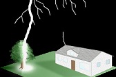
A house was thankfully spared by just a couple hundred feet.

The tornado approached the interstate just east of a county road overpass. Motorists were stopping as this incredible spectacle passed in front of them.

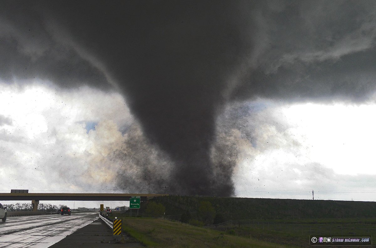
The tornado crossed the interstate about a half-mile to my east with a massive amount of debris lofted.


I got back on the interstate eastbound with the tornado roping out to the north.

This tornado was rated EF3, the first of four EF3s I would witness this day. The full tripoded 4K video of this sequence is here:
I wanted to move north once across the Platte River to avoid potentially getting trapped on the west side of the river. During this move east, three more tornadoes were visible north of the interstate. I din't know what happened during this time until I was able to review my dashcam footage, as I could not maintain a continuous view on the storm while I was driving.


My plan to re-intercept the storm north of Gretna was a mistake. The road was congested with traffic, and long/non-timed lights were stopping me at every cross road. I finally made it to Highway 275 to see the start of a large tornado to my northwest. I did not get any pictures of this due to not being able to find a view (terrain, trees and buildings made it impossible). These are the views of the large wall cloud with the beginnings of the wedge tornado visible underneath.


With more storms approaching from the southwest, I decided I didn't want to be stuck in the Omaha metro any more, and bailed to the interstates and then northeast on I-29 into Iowa. When I re-intercepted the storm at Modale, a new tornado was developing with the next meso cycle, while an old tornado emerged from the rain behind the RFD gust front. I later learned that the old tornado was the same one I'd witnessed the start of west of Omaha.

The old tornado roped out, but its circulation remained visible moving through the town.


I was nearly out of gas at this point, so I had to let the storm go to refuel in Logan. After this, I moved south to Beebeetown to intercept the next storm. It already had a tornado in progress when the meso became visible! I watched this approach for a short time before heading east to give it some more room, once again hearing the waterfall sound.


I turned out this was the EF3 tornado that started at Eppely Airfield and passed near Crescent. The 4K video of this intercept:
After the tornado crossed I-80, I moved east to the next storm at Minden - and again, a tornado was already in progress when I gained a visual on the updraft region.

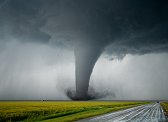
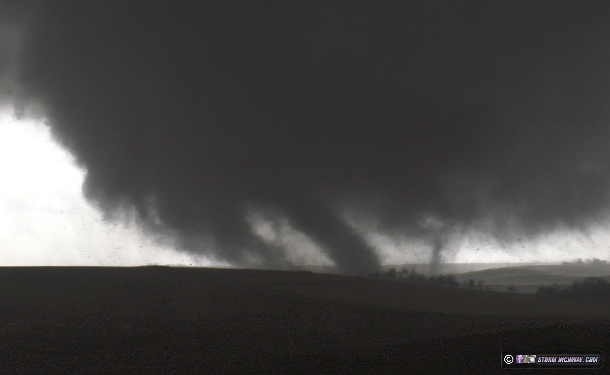
The road from the north into Minden was closed due to construction, so I stopped at the crest of the last hill before town. I observed this tornado - the largest of the day - transition from multiple-vortex to wedge as it moved into the town of Minden with a loud roar.


These views show the Minden's water tower dwarfed by the roaring tornado moving into the town.


As the tornado got a little to close for my comfort level, I moved north to give it some additional room and to observe it pass by to the east. A spectacular show of multiple vortices - some large and strong - danced in the field just to my east as the waterfall sound continued.

I followed behind it as it slowly shrank in size, watching it cross a dirt road about a mile ahead of me.


After the tornado had crossed the road, another tornado condensed to its south. This appeared to be a separate tornado (not a subvortex of the main tornado).

4K video of this sequence:
Moving east north of I-80, I encountered a two-story house that had just been struck. I and another chaser stopped to check on it. The house was still standing but was substantially damaged, all of the windows were gone. The lone occupant and his pets were OK, having ridden out the tornado in the basement. We offered assistance, with the only thing he asked for was to get the garage door off of his mostly-undamaged truck. After neighbors arrived on scene, we both left.
I got back on I-80 and made the long trek through Des Moines down to Winterset where a tornadic supercell was fighting off surrounding storms. I observed a wall cloud with this storm to the southwest with difficulty, as it was getting dark and the terrain/trees at that location were suboptimal. I decided to head down to a supercell ahead of the line at Osceola. I had a feeling of dread as the couplet was quite strong, and it appeared to be heading straight for the town. I observed a cone tornado approach the town in the darkness and then weaken as it approached, as if my prayers for the town were answered. Due to the darkness and lack of lightning directly behind the tornado, my main video camera did not get very clear images of it - but my front dashcam managed to:


I observed what appeared to be a separate tornado getting started to the north of town, with multiple funnels visible under the wall cloud. This storm was moving much faster than the others, and it did not appear that I'd catch up again. I moved south to the tail-end cell in the line, which had a couplet and was tornado-warned, but had no visible structure that I could see. At this point, there were no other potentially-tornadic storms within my reach. I headed south on I-35 through Kansas City, stopping at Ottawa, Kansas for the night.
GO: Home | Storm Expeditions | Photography | Extreme Weather Library | Stock Footage | Blog
Featured Weather Library Article:
|